
10-13-12
We left our beautiful Cottonwood campground at 8:30 AM. I felt guilty leaving that early because it was rather cold in the morning. When I woke up it was 45 degrees F. in the motorhome.
Frank and Rhonda were ready. They went to empty the holding tanks and I got some water and then left for the gas station. We met there and left Chinle.
We arrived at the Sand Island Campground, near Bluff, Utah, at 10:30 AM. This is another colorful area. The pictures do not show the full colors. Some of the trees are in gold already.

After lunch we left for Goosenecks State Park. There the San Juan River is a thousand feet below, where we were standing, and has carved its way like a snake through the earth.
One can see the river around three curves.

Frank took this picture. On my camera the wide angle is too small.


In 2005 I was at the Gooseneck State Park with the WINs. The wind was so strong up there that we almost got blown away. Today we had fine weather.
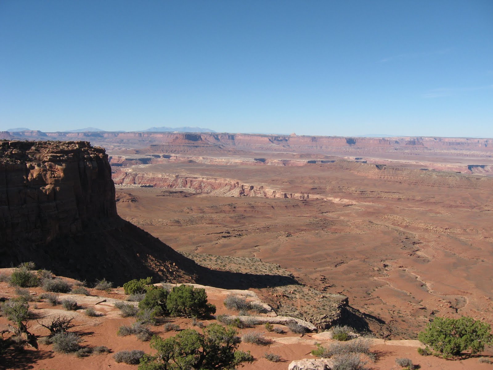
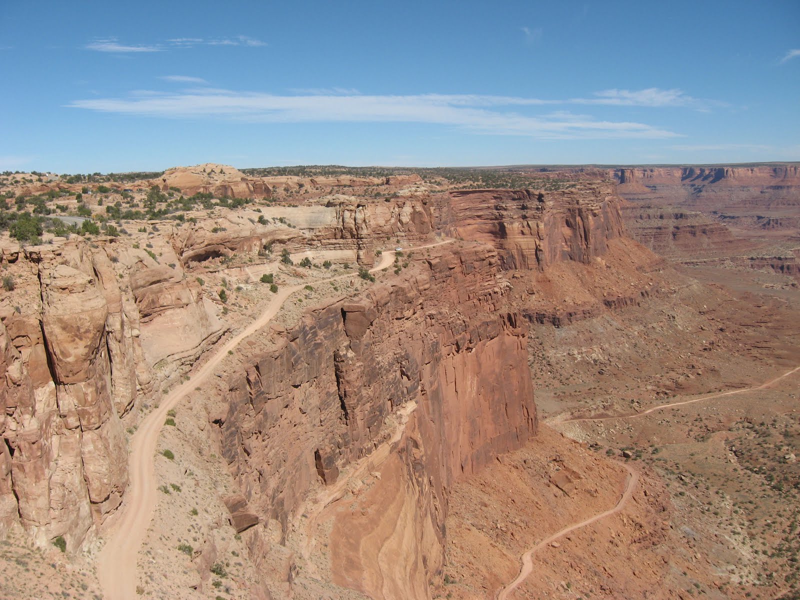
Our next stop was the Moki Dugway. We had to drive up a 10 per cent grade gravel road. The view from up there was worth the drive.


We also went to the Muley Point Overlook. This was not a smart thing to do with a Saturn. The dirt road was wet. Again we had a terrific view over the area. In the back is Monument Valley. Unfortunately it was hazy and the buttes are not much visible in the picture.
On the way back I drove through a big puddle and almost got stuck. The car was in a mess. The red soil is difficult to remove.

To reward us for a good job done we went to Mexican Hat and had an ice cream.
The store is next to the San Juan River.


The Mexican Hat stone formation is outside of town. I suppose the town was named after it.

10-14-12
Today we drove to Hovenweep National Monument. The people who lived here 800 years ago build towers near springs. Some of those buildings were rectangular and some were round.
Many of the towers are right on the canyon rim.
Archeologist believe that the towers were there to protect something, perhaps the water.
In the late 1200s the people disappeared. Why they left is still unanswered. Perhaps the climate changed and they could not grow crops anymore.

The walk was two miles long. First we walked on the rim and then down and up the canyon.


The bench was a welcome place.

When we got back to the Visitor Center we ate our lunch at the picnic table.
Then Rhonda and I went to the Visitor Center and watched the movie about the Hovenweep settlement.
Frank had to stay with the dogs. The car was too hot for them. The park is one of the few where you can take them on the trail.
Back at the campground I walked to the petroglyphs on the wall of the Sand Island Canyon.


We have some beautiful flowers here.

10-15-12
This was a long day. We left at 9:30 AM and came home at 5:00 PM.
Our first stop was the Needles Overlook. The Needles were way in the distance, in Canyonlands National Park. The Colorado River has carved here a several mile wide canyon. The canyon is also very deep.
Pictures cannot show the effect this landscape has on a person.


Then we headed for Newspaper Rock. Ancient people left here their graffiti. From the pictures we can learn about their surroundings. Why one foot has six toes is hard to explain.
The rock has an overhang which protects the petroglyphs.


Along the creek were trees in full fall colors.

In Canyonlands National park are tall buttes and fancy rock formations. We are at the south entrance.


We could not get close to the needles and had to take pictures from a large distance. The slender columns are not visible in the picture.

We stopped at the Wooden Shoe Arch. One does not need much fantasy to recognize the shoe.

10-16-12
Today we went to Natural Bridges National Monument. To really see the bridges one has to go in the canyon. We stayed on the rim.
The Sipapu Bridge is the newest bridge.

The Kachina and Owachoma bridges are bigger and older.


Out of the park is the Mule Canyon Ruin.


On the way home we stopped at the Edge of the Cedars State Park Museum in Blanding, Utah.
It is an outstanding museum with a lot of Indian artifacts.


Rhonda climbed into the kiva. Doreen and I did this seven years ago.

Kokopeli is everywhere.

10-17-12
We had a strange day today. Last night we started preparing for leaving Sand Island. I hooked up the car and Frank and Rhonda went, after the Presidential debate, and filled up the fresh water tank in the motorhome. It was dark by then.
This morning we left at 7:00 AM. I went at 6:30 AM and put some water in my fresh water tank.
We had to leave that early because Frank and Rhonda needed propane gas and the place where they got it fills up motorhomes only between 8:00 AM and 8:30 AM. The place was in Blanding, 30 miles away.
While I left the camp site in the dark I damaged the rolled up awning on the motorhome . So far I do not know whether one or more layers got torn. I have to open the awning to check it out. Right now I do not feel like doing this. I came too close to a tree. Fortunately the rubber membrane on the roof did not get damaged.
Last month was not good for me. This month the bad luck continues with small problems. One of the sections on the mini blinds over the dinette broke. Last month when I shampooed the carpet; I also sprayed the rug in the kitchen. I should have done this in the driveway. The liquid dissolved the backing on the rug and left a dark outline on the kitchen floor.
We got the propane and later Frank topped off the gas tank in the motorhome.
He also went to a RV Park and emptied the holding tanks. I am alone and have bigger tanks in my motorhome.
We were ready to continue dry camping.
When we arrived in Moab, Utah we looked for a public campground next to the Colorado River. The place was full.
Frank suggested that I lead looking for the next campground. This was a big mistake. I saw the next campground, but what I thought was the entrance, was only a parking lot with no exit.
We had to unhook the cars and turn around. There was no room doing it with the cars attached.
I drove to the campground looking for a site. The sites there were too short for our motorhomes.
We were lucky not to drive there with the motorhomes because there was no room to turn around, even with the cars removed.
Our next stop was the Gold Bar BLM Group Campground. The WINs use it when they are in this area. They make the proper reservation. We could have stayed for two days, but the next three days were reserved. We plan on staying five days in Moab.
Frank called a RV Park in town and they still had sites available. We went there and have full hook-ups, even cable television.
They even sell propane here at the RV Park.
In 2005, when I was here with the WINs I did not have all those problems. Jim Kelly and Lola Gonzales did such a good job organizing the trip. The only glitch we had in Bluff. We were parked at the County Airport. When the local campground owners saw all those motorhomes at the airport they forced the airport manager to make us leave. I think we were more than 30 rigs and would have never found a RV Park to accommodate all of us.
10-18-12
This was a glorious day. The temperature was in the low seventies with a blue sky.
We went to Arches National Park, one of my favorite places.
Some of the trails to the arches are long. Rhonda did very well. We were worried about her, but she said: “We are here and we might as well do it”.


I was surprised how many parents with children were in the park. Either it was a school holiday or parents in Utah home school their children. Families are large here.

We did not walk the Delicate Arch trail. It was one and a half mile one way and there was climbing over rocks involved. We had to be satisfied looking at it from a viewpoint.


Some of the formations are so beautiful.

In some areas are several arches close together.


Here are the Window Arches.

The Turret Arch is one of the large ones.

10-19-12
We went back to Canyonlands National Park. This time we did the northern section.
The Colorado River cut a wide canyon through the land.


At the Upheaval Dome Picnic Area we ate our lunch.

At the Shafer Canyon Overlook one can see the dirt road used by the company which mined uranium in this canyon.

Our next stop was the Dead Horse Point State Park. From the overlook in the park the Colorado River can be seen. The view is out of this world. It was a bit hazy and not the best time for picture taking.
The river is two thousand feet below the overlook.


In the valley there is a salt making plant. They flood a large area and wait until the water is evaporated and then harvest the salt.

This was another terrific day.
I opened the awning today and the hole is about three inches by six inches. The material stayed with the tree branch. If the material was still there I could have fixed it with the clear awning tape I have.
10-20-12
This was laundry day. I did my laundry here at the RV Resort. Rhonda and Frank went to a Laundromat.
They needed bigger washing machines and bigger dryers.
After doing the laundry I went to McDonalds and got on the Internet. The system in the park is too slow.
On the way home I stopped at the City Market and bought groceries. This place is a gold mine. It is the only big store in town.
The store belongs to Kroger and with the card I saved $ 4.00 on a $ 26.00 purchase. It is a gimmick, but one has to play the game. I have about ten store reward cards.
The afternoon was reserved for just hanging around. Frank and I sat outside and talked.
Moab is filled with people during the week and on weekends crowded. This is the place to go bike riding, four wheeling, kayaking, and sightseeing.
The scenery is just fantastic and spectacular.
Last evening a lot of people arrived and we have neighbors who set up two big tents. They have large families here in Utah.
In the evening there are many camp fires and going to bed early does not pay. There is too much talking out there, and having fun.
10-21-12
We tried to drive the La Sal Mountain Loop Road Scenic Byway this morning.
Our first stop was in Castle Valley. The mountains and colorful trees next to the creek were a beautiful sight.


When we came up La Sal Mountain we had to stop and turn around. There was a barricade. When the Spanish Explorers came through the valley in the summer and saw the white capped mountains, they did not believe there was snow up there. They thought it was salt and called them the salt mountains.
We went back to Moab and watched a movie at the Arches National Park Visitor Center.
After lunch we drove to Hole in the Rock. This was a restaurant cut in the rock. It is a museum now, with a little zoo and stores.


The Jeep is made of license plates, and the wheels of bolts, tools and other stuff.


This is our last day at this spectacular place.
1 comment:
Looks like you're having a great trip despite the torn awning. I bet Moab is even a good temperature right now. Have fun!
Post a Comment